Operations

Grand Coulee Dam was built as part of the Bureau of Reclamation’s Columbia Basin Project to provide water for agriculture in central Washington State.

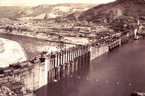
When construction of the dam was completed in 1942, the waters behind the dam rose by 380 feet to an elevation of 1,290 feet above sea level.

The Columbia River from the Canadian border to the dam was no longer free flowing. Instead, this portion of the Columbia became a reservoir (called Franklin D. Roosevelt or Lake Roosevelt for short). At full pool, Lake Roosevelt has 630 miles of shoreline and extends north over 150 miles to the Canadian border.

As authorized by Congress in 1935, Lake Roosevelt and Grand Coulee Dam were designed to primarily support irrigation, flood control and power generation needs. Over time, Lake Roosevelt’s operations also sought to meet the recreation needs of up to 1.5 million people annually, and the water needs of downstream fisheries.

Lake operations refers to the ability of the Bureau of Reclamation, in concert with the U.S. Army Corps of Engineers (the Corps), the National Oceanic and Atmospheric Administration (NOAA) Fisheries, the Bonneville Power Administration (BPA) and other agencies, to raise and lower lake levels to meet irrigation, flood control, power generation, fishery, recreational and other needs.

From an operations perspective, the lake can fluctuate between minimum and maximum lake elevations. At its maximum, the lake’s elevation can rise to 1,290 feet above sea level and can hold over 9,000,000 acre-feet of water. That’s enough water to cover the states of Washington and Oregon with more than one inch of water. The minimum lake level for normal operations is 1,208 feet above sea level. So if you can imagine raising and lowering water within an eight story building that’s one half to one mile wide and over one hundred miles long, that’s the “box” within which Lake Roosevelt’s operations are managed.

Part of the importance of Lake Roosevelt is also its ability to refill. The run-off from rivers and tributaries into the lake allows it to refill about seven times in an average water year. By comparison, one of the other large reservoirs in the region, Hungry Horse, could not refill in the same year if it were emptied.

Meeting the many and varied operational demands put on Lake Roosevelt are very complex for two reasons. First, the multiple purposes Grand Coulee Dam and Lake Roosevelt support can cause conflict. For instance, flood control needs mandate that by late April or early May Lake Roosevelt be drawn down to a level that provides a high probability that downstream flood control needs will be met. This action, however, can affect the amount of water available to assist with flows for downstream fisheries. Likewise, spring draw downs of the reservoir must be done in a manner that assures for refill of Lake Roosevelt by summer. This refill affects not only meeting recreational needs, but the availability of water releases to assist downstream fisheries in August/September.

The second ongoing complexity is the hydrologic (or water) cycle. Weather patterns are unpredictable from year to year, month to month and sometimes week to week. As such, the best laid plans of managers in predicting things like the rate of runoff due to snow melt may need to be modified quickly and with little warning. Several teams of managers from both public and private agencies assist with various processes that help determine operational decisions. A decision group of particular importance is the Technical Management Team (TMT), an inter-agency technical group responsible for making recommendations on dam and reservoir operations along the Columbia. The TMT web site is one of the best resources available for operational, water supply, fish passage and related plans.

This section briefly reviews how Lake Roosevelt’s operations are managed to meet its many purposes. To see a hydrograph showing examples of how lake elevations change during wet, dry and “average” years to meet operational demands, LINKclick here.

The Columbia River is one of the longest rivers in the United States.

Like any river, it is ecologically inseparable from its watershed and basin. A watershed is the land area that delivers runoff, sediment, and dissolved substances to a river and its tributaries.

The Columbia Basin spans seven states and one Canadian province. The northernmost reach of the basin is found in the high glaciers of the Canadian Rockies. From there, the main body (or stem) of the Columbia River runs over a thousand miles before passing Portland, Oregon and reaching the Pacific. The Columbia River and its tributaries account for about 219,000 square miles of drainage in seven western states, making it almost the size of Texas.

In years with lots of rain or snow, flooding in low lying areas and the lower river, especially near Portland, would be common without flood control. To meet this need, Grand Coulee is one of the dams on the American side of the Columbia River with reservoir capacity sufficient to help prevent flooding. On the Canadian side, additional dams and reservoirs assist with flood control. Via a treaty with Canada and sophisticated interagency planning, up to 39.7 million acre feet of storage space can be made available for flood control. This space is made available by drawing reservoirs down and then capturing spring runoff to refill the reservoirs rather than causing downstream flooding. By making up to 5 million acre feet of space available for flood control, Lake Roosevelt is the system’s primary American storage area.

Forty-eight years of developing this coordinated approach came together as never before in February, 1996. Heavy rains and melting snow pack due to mild temperatures created the worst flooding in over 30 years in the Northwest. Government agencies and non-federal hydro operators worked together to reduce flood damage by an estimated 3.2 billion dollars. Because the Northwest had a flood control plan in place, the evening news did not show downtown Portland six feet deep in water.

In an average year, a year with 100 percent of normal precipitation, Lake Roosevelt is lowered about 50 feet in April and May to insure against downstream flooding of communities and property. The flood control “season” essentially lasts between April and July. The Corps, by federal law and through a formal agreement with the Bureau of Reclamation, sets the elevation of Lake Roosevelt based on daily, weekly and monthly forecasts. Statistical models, weather reports, runoff information and interagency cooperation are all used to create forecasts and manage lake levels for flood control purposes.

Annually, about 2.5 million acre feet (or over 814 billion gallons) of water is pumped from Lake Roosevelt into Banks Lake to support irrigation.

Generally, these water diversions occur between March and October. Via canals and other means, water from Lake Roosevelt irrigates about 670,000 acres of land. Combined with the naturally rolling countryside, nourishing and drainable soil, a long growing season, and breezes strong enough and frequent enough to minimize frost pockets, the result is one of the world’s most bountiful croplands. A map of the irrigable lands shows that they reach as far south as the Tri-Cities and irrigate lands in four different counties.

Without irrigation, this bounty would not be possible. Farmers and ranchers could not sustain operations with, at best, six inches of rainfall that mostly fall before the summer growing season. Before irrigation was introduced, lack of rain combined with the searing heat of the high desert environment drove people with the best of intentions from the land they came to till.

With irrigation, which officially began in 1948, about 6,000 farms sustain more than 60 crops. Diversity extends from potatoes to peppermint, with the largest crops including over 260 million pounds of apples and about 20 million bushels of wheat and corn. In addition, there is dairy farming and 200,000 beef cattle. Annually, the Columbia Basin Project farms earn about 630 million dollars from their crops.

Irrigation water is pumped from Lake Roosevelt by the Grand Coulee Pump-Generating Plant. Here, 12 huge pumps lift the water up 280 feet into Banks Lake, which is a 27-mile-long reservoir that extends south to the town of Coulee City. A main canal then takes the water to three large canals that extend a total of 333 miles and serve as main arteries to laterals. Almost 2000 miles of laterals carry water to croplands for irrigation.

Grand Coulee Dam is the largest hydroelectric facility in North America.

It has a generating capacity of 6,809 megawatts of electricity, enough to meet the needs of over 4 million residential customers a year. Of the 250 hydroelectric projects (both public and private) that generate five or more megawatts of electricity in the Northwest, Grand Coulee accounts for about 20% of this capacity. As a result, many people refer to Grand Coulee as the “work horse” for the Federal Columbia River Power System*.

Ironically, Grand Coulee was not built with the notion that it would play a central role in meeting the Northwest’s electricity needs. Indeed, in 1935 power generation was mostly seen as a way for paying back the costs of construction and pumping for irrigation. It was not until two years later that the Bonneville Power Administration was created to market and distribute power from federal dams in the Northwest. When the first power generating unit was brought on line in 1941, it served as a critical asset for producing aluminum and other energy intensive materials needed for World War II.

Today, Grand Coulee Dam consists of four power plants and 33 massive turbines. Water is carried from Lake Roosevelt into each turbine through a penstock, a huge pipe that (depending on which turbine is being fed) varies between six and forty feet in diameter. The force of rushing water spins each turbine, which in turn spins a shaft that rotates magnets around coils inside a generator. The resulting electricity is carried to switchyards where it is transferred to over 22 transmission lines. These lines carry Coulee’s electricity to towns and cities throughout the Northwest and beyond.

The waters of Lake Roosevelt function as a renewable fuel source for the turbines at Grand Coulee. A particular advantage of Grand Coulee is not only its size, but its ability to store water in Lake Roosevelt for future use. With storage, turbines can quickly be brought on and off line as demand changes. For instance, in the morning, when hot showers and toasters require more electricity, Grand Coulee responds. This type of demand is called peaking, and hydropower facilities (as opposed to coal and nuclear plants) can do this much more quickly and economically.

Grand Coulee, however, can not simply draw water from Lake Roosevelt to produce power whenever the Bureau of Reclamation wishes. Two agreements, the Pacific Northwest Coordination Agreement (PNCA) and the Columbia River Treaty, underpin how the system functions in a coordinated fashion. The Treaty was signed in 1961 with Canada , and PNCA took effect in 1964. The Canadian treaty requires joint planning of river operations at six year intervals and on an annual basis.

The PNCA was signed by the Bureau of Reclamation, BPA, the Corps, and 15 public and private generating utilities. With PNCA comes the ability to coordinate operations among federal, public and private owners. At the heart of PNCA is a set of operating rules. These rules are then used to create a set of “rule curves” that govern the amount of firm energy (the amount of “guaranteed” power) that each project can produce during particular months. These parameters form the basis for operating the entire system. How rule curves are set and the amount of coordination that must occur is, of course, fairly complex.

The amount of non-firm power (the non-guaranteed power that Grand Coulee can generate and BPA can market) is highly variable from year to year. First, there must be a demand for the electricity that results in it being profitable for BPA to market. Second, Lake Roosevelt can not be drawn down in a way that refill for the following year can not be guaranteed. And lastly, drawing the lake down to support non-firm energy must be balanced with other purposes. These include, for instance, needs to keep the lake elevation high enough for summer recreational needs, low enough to meet flood control needs, or high enough to allow for water releases to help migrating salmon downstream.

On a season by season, month by month, and day to day basis it takes a team of people to make these operational decisions happen.


*The Federal Columbia River Power System (FCRPS) includes:

  • the transmission system constructed and operated by BPA and
  • the hydroelectric dams constructed and operated by the U.S. Army Corps of Engineers and the Bureau of Reclamation in the Northwest

Each entity is separately managed and financed, but the facilities are operated as an integrated power system.

There are over 30 species of fish in Lake Roosevelt.

Annually, over 500,000 rainbow trout and 500,000 kokanee are stocked in the lake through the use of hatcheries and net pens. Lake operations, however, are most often affected by the needs of downstream fisheries, particularly anadromous fish (salmon). With 12 species of fish being listed as endangered, the NOAA Fisheries and the U.S. Fish and Wildlife Service began consultations with federal “action agencies” (the Bonneville Power Administration, the Army Corps of Engineers and the Bureau of Reclamation) to determine and address the affects of Columbia River (including Lake Roosevelt) operations on these fish.

Beginning with the 1995 Biological Opinion, which was most recently updated in 2000, the action agencies began developing and implementing an annual Water Management Plan to assist meeting the Biological Opinion’s fishery objectives. In general terms, this includes managing flows to avoid stranding resident fish, speeding downstream migration of juvenile fish, meeting the water temperature needs of fish, and avoiding creation of dissolved gas conditions that can adversely affect fish.

Specific to Lake Roosevelt, guidelines affecting fisheries include:

  • Within the criteria of reducing lake levels to meet flood control rule curves by April 30th, provide water releases to increase available downstream flows for fish during the spring. For instance, lake levels are commonly drawn down for flood control until May 1 or later. Refill is often delayed to provide additional water for downstream fisheries.
  • Spring water releases, however, must also accommodate refill of the lake by approximately July 4th. During the spring period, one sensitive area is the lake level at the end of May, when net pens release rainbow trout and kokanee. Release conditions are best at an elevation of 1265 or higher. At this level, entrainment (loss of fish through Grand Coulee Dam) is reduced because water flows are weaker. Released fish, therefore, can more easily migrate to bays and outlets. In addition, the fish generally need to be released by the end of May to avoid diseases that occur as a result of their reaching a size and maturity that no longer make their retention in a net pen appropriate.
  • During July and August, lake elevations generally fluctuate between 1278 and 1290. Within the guideline of not reducing the lake level below 1280 unless criteria for a below average water year are met (in which case the lake can be reduced an additional two feet) water can be released to assist downstream juvenile salmon migrating to the ocean.
  • In the Fall there is an effort to maintain lake levels between 1283 and 1285 feet during the month of October. This is to assist with Lake Roosevelt’s kokanee fishery, specifically brood stock collection and assuring their access to tributaries.
  • Fall and winter lake levels may be used to support flows for spawning downstream Chum Salmon.
  • Banks Lake, which has water pumped to it from Lake Roosevelt, is lowered to an elevation of 1,565 feet by the end of August to leave additional water in the Columbia River for summer flow augmentation. Currently, an environmental analysis is being conducted to determine if Banks Lake can be drawn down an additional five feet during this time period. Click here for more information.

Lake Roosevelt has more than 600 miles of shoreline.

This ribbon of shore ranges from 100 to 300 feet wide when the reservoir is full—and even wider when water levels are lower. Recreation was not one of the purposes authorized by Congress when Grand Coulee Dam was constructed and Lake Roosevelt came into being.

Today, however, between 1 and 1.5 million people recreate around Lake Roosevelt each year. Most of this recreation occurs in the summer when the weather is hot and camping, boating, fishing and swimming opportunities abound.

To support recreational needs, the lake is generally brought to an elevation level of 1280 or above by July, and remains between 1280 and 1290 throughout the summer. This assures that boat launches, campgrounds and swimming areas can be optimally used.

Between 1992 and 2002 there were serious drought and flood control conditions. Regardless of these conditions, the lake did refill in time to meet summer recreational needs. Click here to see the water elevations graph for those years.

Learn more about the many recreational opportunities associated with Lake Roosevelt in the Recreation section.