


Annually, up to 1.5 million visitors and community members swim, fish, play on the beaches, and tap Lake Roosevelt for drinking water.
To ensure that human health issues are addressed, the Washington Department of Health (DOH) prepares health consultations and, as needed, issues and/or updates advisories. Information in this section is based on DOH findings whenever possible.
EPA's human health risk assessment is not expected until 2013.
Are the Fish Safe to Eat?
The Washington DOH fish consumption advisory provides guidance for safely consuming fish in Lake Roosevelt. Click here for the most recent advisory.
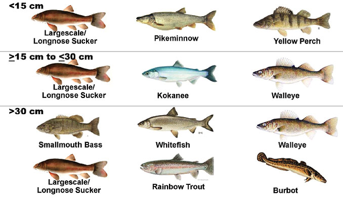
In the fall of 2009 over 2,300 fish were sampled as part of the RI/FS. Sampling included all size classes (small, medium and large) and a wide range of species (see Fish Species Sampled). Sampling occurred throughout the upper Columbia and Lake Roosevelt (see Study Areas for Fish, Surface Water and Beach Sampling).
Samples were tested for an array of inorganic and organic compounds. Examples of inorganic compounds include mercury and heavy metals such as arsenic, cadmium, copper, lead and zinc. Examples of organic compounds (which are man-made) include PCBs, dioxins/furans, PBDEs, and pesticides.
EPA's draft data summary report and preliminary findings indicate concentrations of metals and mercury in fish are similar to or slightly lower than those measured in 2005. EPA will use results of this sampling for its human health risk assessment (which is not expected before 2013) and its ecological risk assessment (which is not expected before 2014).
Web pages maintained by EPA and Teck provide the most recent information available.
Lake Roosevelt Fish Consumption Advisory and Statewide Mercury Advisory
Fish in Lake Roosevelt contain chemicals, including mercury that may be hazardous to your health. Women who are or might become pregnant, nursing mothers, and young children may be especially at risk.
These individuals should limit the amount of fish they consume from Lake Roosevelt to:
- 2 meals per month: smallmouth bass, largemouth bass, and walleye, or
- 4 meals per month: sucker or burbot, or
- 2 meals per month of any combination of species listed above.
- Do not eat northern pikeminnow.
Largemouth bass, smallmouth bass, and northern pikeminnow were not sampled from Lake Roosevelt, but are listed on the Washington Department of Health's Statewide Mercury Advisory.
To Reduce Your Exposure When Eating Fish
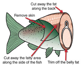 Prepare fish the following way to reduce PCBs and other contaminants that collect in the fatty parts of the fish by up to 50 percent:
- When cleaning fish remove the head, skin, fat, and internal organs before cooking. Do not use for sauce or gravy.
- Grill, bake, or broil fish so that the fat drips off while cooking.
- Mercury is stored in the muscle (fillet) of fish and cannot be reduced by cleaning this way.
Check local fish advisories: 1-877-485-7316 or www.doh.wa.gov/fish.
Beach Exposure
 A 2009 Health Consultation from the Washington Department of Health, based on EPA sampling collected in 2005, concluded there is "no apparent public health hazard."
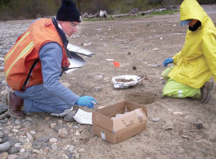
The 2005 EPA sampling included fifteen beaches. The criteria used for assessing exposure were children or adults being exposed for two days per week for four months, or 35 days per year for area residents. In both cases "DOH concludes that touching, breathing, or accidentally eating sediment ... is not expected to harm people's health."The 2009 health consultation can be found at http://www.doh.wa.gov/Portals/1/Documents/Pubs/334-228.pdf.
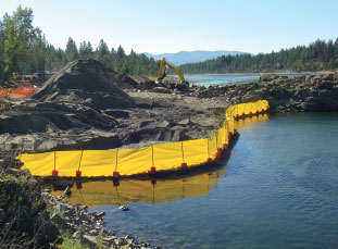
Due to lead and arsenic concentrations that were above screening levels, EPA required additional testing at Black Sand Beach, Northport Boat Ramp and Dalles Orchard. In these cases:
- In 2010 Teck agreed to remove and replace about 9,100 tons (approximately 6,500 cubic yards) of sediments containing granulated slag from Black Sand Beach. Slag was hauled to Trail, British Columbia for recycling, and clean fill material was used to establish the new beach. Teck conducted this action voluntarily under an agreement with the Washington Department of Ecology Toxics Cleanup Program that was independent of the RI/FS.
- EPA is currently evaluating contaminant data from the 2009 and 2010 beach sampling events. The results of this analysis will be available in late summer 2011 and will be shared with the public in an EPA fact sheet.
Consultation with tribes, state and federal agencies also led EPA to request testing at 33 additional beaches, many of which are campgrounds or used by local residents. Sampling at two of these beaches was conducted in 2009, and five of these beaches in 2010. In spring 2011, additional sampling occurred at 26 beaches. The Beach sampling list (see page 5) notes what beaches were sampled and when, including six that were tested more than once.
EPA's preliminary findings from 2009 and 2010 beach sampling are similar to those for 2005. Further, all of the beach results will be examined in greater depth in the EPA Human Health Risk Assessment, which is not expected until 2013.
2005, 2009, 2010 and 2011 Beaches Sampled for Potential Public Exposure to Contaminants:
|
|
 Surface Water
Preliminary findings from surface water sampling indicate Lake Roosevelt is safe for swimming and recreation.
In more technical terms, undisturbed surface water sample concentrations for arsenic, cadmium, copper, lead, mercury, zinc and organics (e.g.-PCBs and dioxins/furans) are within limits protective of people and aquatic life.
Samples were collected in three different ways: unfiltered, filtered and disturbed. Disturbed water samples simulate a recreational situation, like a child running and playing in the water, where someone kicks up mud and other beach sediment. Specifically, these samples collect suspended sediment in shallow water near the shoreline. For disturbed water, aluminum, barium, iron, lead, manganese and nickel levels exceeded federal drinking standards in some samples.
Extending from the Canadian border to Grand Coulee Dam, surface water samples were taken from shore to shore in six locations and at different depths. Samples were also taken at three different times of year to determine whether differences in lake levels and water flow impact contaminant concentrations. In total, over 67,500 analyses were performed for the surface water sampling program.
Study Areas for Fish, Surface Water, and Beach Sampling

Recreational Use Survey
The recreational use survey will help determine if any human health risks may exist from exposure to contaminants.

From fall 2010 through fall 2011, 3,500 to 4,000 residents and visitors to Lake Roosevelt are being surveyed to determine how they spend their recreational time. Of critical importance are questions specific to activities that potentially expose people to contaminants. For instance, what types of fish are caught, where are they caught and how often are they consumed; what beaches are visited, type of activities pursued and when are they visited; and location, amount and use of surface water for drinking.
Ultimately, information from the recreational use survey will be paired with sampling data from fish, beach and surface water studies in EPA's Human Health Risk Assessment. Sampling data provides the picture of where contaminants are and in what concentration (be they dissolved in the water, on a beach or within fish tissue). Risk assessors will combine the sampling data with the survey data to estimate if visitors may be subjecting themselves to an unacceptable human health risk.
Surveyors will contact visitors at boat launches, marinas, day-use beaches and campgrounds. How often surveyors are in an area will reflect seasonal, day-to-day and location based visits typical of the area.
For similar reasons, a consumption and use survey is being taken of people living on the Colville reservation. For information about this survey, contact EPA or the Colville Confederated Tribe.
Air Inhalation
A report prepared for the Department of the Interior by Industrial Economics, Incorporated found that human inhalation of airborne sediment particles containing lead and other heavy metals are within EPA acceptable risk standards for cancer and non-cancer health effects resulting from both acute and chronic exposures.
From 2002 through 2006, the United States Geological Survey (USGS) collected air samples from Inchelium, Seven Bays, Kettle Falls (2002) and Marcus (2003-2006). Wind-blown dust events created by exposed, dried sediments has been a long-standing concern by some members of the community. USGS reported that overall concentrations of particulate matter recorded at these monitoring stations did not exceed Federal standards (e.g., the National Ambient Air Quality Standards). In addition, analysis by USGS found that concentrations of metals in the air did not exceed California EPA air quality standards for arsenic and cadmium. Federal and state standards are not available for other metals.
The Department of the Interior requested Industrial Economics, Incorporated (IEc) to further evaluate the USGS data. The report focused on potential exposures and risks to non-tribal people, e.g. - - residents, park employees, and visitors. IEc found the risks from inhalation of windblown sediment to be below EPA standards and benchmarks for all contaminants and scenarios evaluated.
EPA will further evaluate air inhalation concerns as a part of the RI/FS Human Health Risk Assessment that is not expected until 2013.